Home
Up
Arizona Thunderstorm Chasers - July 12, 1995
![]()
July 12, 1995 Chase
July 12, 1995 was scheduled to be a practice chase starting at 4PM. As it turned out, a large thunderstorm developed NE of Tucson and propagated northward. It produced a gust front that moved through the Phoenix area kicking up isolated cells along the front. The cells were high based and produced brief heavy rain and a number of wet microbursts, at least one of which produced damage in Chandler, AZ.
The team I was with stopped at Chandler Road and Val Vista and watched the situation develop. Before it was over, we had seen three gustnados to the SE, a classic microburst (see pictures below) to the SE, and microbursts also to the north and east of us.
![]()
July 12, 1995 Pictures
These pictures were taken with a Canon A1 Digital Hi-8 video camera, and then digitized using a Snappy digitizer (attached to the printer port).
For some reason contrast in the video was not as good as could be desired (perhaps because these clouds don't have a lot of contrast?).
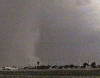
The most dramatic microburst, which also triggered three gustnados, was SE of us 10 to
20 miles (it is hard to tell with high-based storms). It is shown in the following
sequence:


The gustnado video came out pretty poorly, but here is one snap from it:

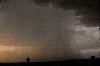
Another microburst happened right around sunset, to the north of us. It doesn't show a
good microburst foot however:
![]()
![]()
last update 07/24/95
![]()