So... we decided to head west out I-40 back to NM. However, by the west side of AMA, we could see what appeared to be a storm to our SouthWest. One in the hand is often better than one in the bush... so we went after it.
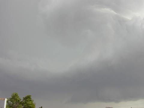
Eventually we ended up in Abernathy (in Hail County), where we watched a well organized low feature approaching us. At first we thought it was an arcus riding an outflow, but some things weren't right about that... it had a pronounced green hail color in it (see picture - which doesn't do it credit). It had lightning from it. And, there was an increasingly strong wind flowing into it from the NE - up to a sustained 25mph.
We took the picture shown on this page, and should have taken more. The side nearest to us had a distinct anticyclonic "cinnamon-swirl" rotation. Although it looks vertical in the picture, it was actually a horizontal feature. The side of the storm to the west had a rain free base with persistent cyclonically rotating light scud.
Shortly after taking this picture, hail started to fall. We ducked under the I-29 overpass 100 yards away, and took movies of the crowd ducking in there, and the golf-ball sized hail falling just outside. Later storm reports indicated baseball sized hail 8 mi west had done significant damage.
Based on the arrival time of the cloud feature vs. the hail and outflow winds, it appears that the feature described above were *not* outflow induced.
After the hail left, we snuck out to chase the storm, got hammered by large hail within 1/2 mile, and dashed back to our shelter.
When it had all died down, we went west to chase the next storm, reported by LBB radio to be near LBB. As we approached Littlefield, we observed a very interesting LP-ish supercell. It had nice laminations and striations, and had a smooth bell shape with other, hard-to-classify striated stratiform clouds around it.
We needed gas so pulled into a station, commenting at the time that it's cover over the pumps would provide hail protection - although at the time there was little precip from the storm. We planned to fill up and then chase it. Before the pump started, heavy hail up to 3/4 inch started and lasted for quite a while. When it was done, it looked like our storm had died out (wrong - we heard later on NWS radio).
At this point it was near dark. We decided to head back towards Lubbock, taking a route that might intercept one more base. As we drove, we observed a beautiful supercell to our far NW. We could see the base almost reaching the group, a nice backsheared anvil, and a rock hard updraft. Too far to chase, though. We later found out that there were three tornado warnings issued on it in eastern NM.
Got to the hotel about 10PM - an early night. Spent the next hour or so on the phone to Earthlink support, and through trial and error we fixed the problem (technically - DNS was not working, except via nslookup. Stopping the DNS client service fixed it).